Rectangular Survey System |
For most of the United States West of the the "Colonies" . . . A system of rectangles has been established to locate, and specify the boundaries for land parcels. The following description should help understand what it's all about.
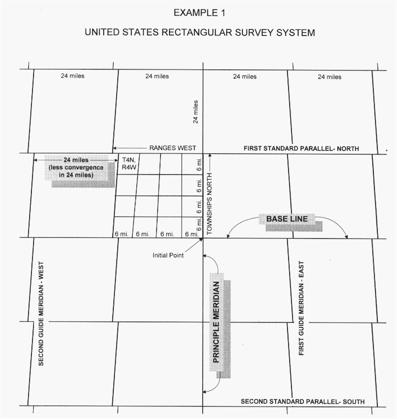
The Rectangular Survey System provides for a unit of land approximately 24 miles square, bounded by base lines running east and west, and meridians running north and south. This 24 mile square is divided into areas six miles square called townships. Townships are further divided into 36 sections, each one mile square.
Base Line and Principal Meridian. The first step in implementing this survey system in a given area is the establishment of an initial point. This point will be the basis for all government surveys in the area it controls, and its latitude and longitude are fixed by astronomical observations. From this initial point, a Principal Meridian is run north and south on a line that would intersect the poles, and a Base Line is run east and west on a parallel of latitude. The Principal Meridian controls survey lines east and west, and the Base Line is the north and south control.
Guide Meridians and Standard Parallels. Because of the curvature of the earth, additional lines called Guide Meridians are run every 24 miles east and west of the principal Meridian. Other lines, called Standard Parallels, are run every 24 miles north and south of the Base Line. The parallels north of the Base Line are designated First Standard Parallel North, Second Standard Parallel North, and so forth, and those south as the First Standard Parallel South, Second Standard Parallel, and so on. Standard Parallels are also called correction lines.
Ranges and Townships. North and south lines are next run on true meridian from Standard Parallels and 6 miles apart, marking the survey area into strips 6 miles wide called ranges which are numbered east and west from the Principal Meridian. Similar lines are run at every 6 mile point north and south of the Base Line, and parallel with the Base Line, dividing the ranges into 6 mile squares called townships. The first township north of the Base Line and east of the Principal Meridian is identified as Township 1 North, Range 1 East, the second township north of the Base Line as Township 2 North, Range 1 East, and so on.
Because meridians converge toward the poles, townships cannot be perfectly regular. Because of this and surveying errors, irregularity occurs and the sections along the north boundary and the west boundary of each township contain these discrepancies. Quarter sections along the north and west boundary take up the excess or shortage in the township. Their quarter quarter sections do not contain the standard 40 acres and are known as "fractional lots" or "government lots". They are assigned unique lot numbers at the time of the survey. For example, Lot 2, Section 5 Township 42 North, Range 12 East; or Lot 7, section 31, Township 41 North, Range 9 East, and so on. See Example 1 below.
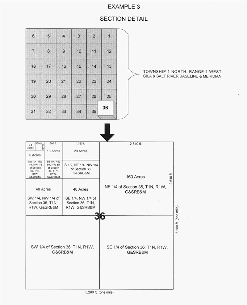
Sections. Townships are subdivided into 36 parts, each one mile square, called sections. This is accomplished by running each way through the township lines which are parallel to the south and east township boundaries. The 36 sections into which the township is divided are numbered from 1 to 36, beginning with the northeast corner and proceeding west and east alternately through the township. See Example 2 for an illustration of a township divided into one mile square sections. Such a section would contain 640 acres.
Further subdivisions are made by the division of the sections into quarters containing 160 acres, and named the northeast quarter, northwest quarter, southeast quarter, and southwest quarter. The quarter sections may be divided into quarter quarter sections of 40 acres and these quarter quarter sections further divided into quarter quarter quarter sections of 10 acres. While sections may be divided into even smaller units of 2.5 acres, 10 acre portions are usually the smallest. See Example 3 below.
In some states, a township frequently will be occupied partially by Indian Lands. The United States Government Surveys did not cover these lands, and an intersection with the boundaries of them resulted in fractional townships. Fractional quarters are also created by the meander line of a body of water.